榎田建築物防災技術研究所では、
特許技術を活用した災害発生予測で、
皆様の暮らしの安全を守って行きたいと考えております。
メッセージ
 榎田建築物防災技術研究所では、災害発生予測(地震・竜巻)・建築物津波防災を中心に研究をしています。
自然災害の発生数が増加している昨今、前もって「身体の安全を守る」「災害を避ける」ことが大事なことであり、その為に当研究所では、特許技術を活用した災害発生予測で、皆様の暮らしの安全を守って行きたいと考えております。
当研究所について、情報提供・サービスに関するご相談・ご質問等ございましたらお気軽にお問合せください。
特許概略
特許の内容の概略を説明します。
データ解析方法、データ解析装置およびデータ解析プログラム
特許第4595083号
データ解析方法は気象画像の輝度値解析に利用しています。 画像の輝度値の低い値の低明度と高明度地域の確定に必要で、データの線形補間により滑らかな曲線を作成することで、その地域の明度値の確定がより明確に決定出来ます。
DATA ANALYSIS METHOD, DEVICE, AND PROGRAM
PROBLEM TO BE SOLVED: To provide a data analysis method, device, and program for causing the regression of a group of discrete data to a Fourier series with a high accuracy of approximation or for facilitating data analysis to create a denser and smoother three-dimensional topographic image from given numerical values of altitude.
SOLUTION: A group of data for regression are created from both a group of discrete data and a group of data symmetrical to the final data of the group of discrete data and are caused to regress to a Fourier series, the group of discrete data being obtained from luminance values on a predetermined measuring line on an image. The number of terms of the Fourier series is a predetermined one smaller than the number of data of the group of data.
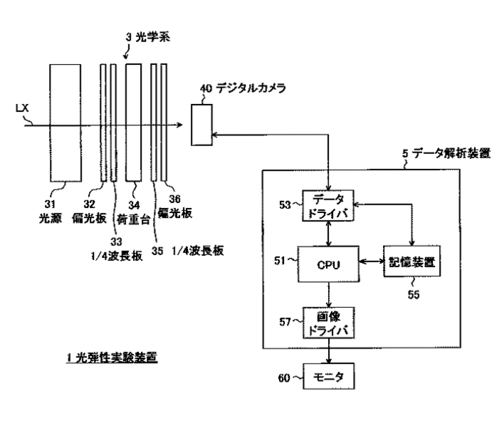
榎田、データ解析方法、データ解析装置およびデータ解析プログラム、特許第4595083号(特願2004-215457)、登録日2010.10.1
特許内容はhttps://www.j-platpat.inpit.go.jp/web/all/top/BTmTopPageで参照可能です。
気象画像解析装置およびその方法、並びにプログラム
特許第5340612号
気象画像解析装置ではその低明度値と高明度値の明度差を求めて、地形上の時刻変化を逐次解析します。これにより、一定地域の通常時と異なる明度変化、すなわち地盤の温度変化の現象を検討します。また、気象データと地盤の温度変化の混在した画像解析のため、地震発生予測外の解析も重複する可能性が有ります。
DEVICE FOR METEOROLOGICAL IMAGE ANALYSIS, METHOD THEREFOR AND PROGRAM
PROBLEM TO BE SOLVED: To provide a device for meteorological image analysis capable of accurately detecting the occurrence of meteorologically abnormal conditions, such as tornadoes and gusts, using image data of a weather satellite, and to provide a method therefor and a program.
SOLUTION: The device 10 for meteorological image analysis to analyze weather image data by a weather satellite has a processing part 17 that puts acquired weather image data on terrain data, sets a plurality of brightness values, deletes the weather image data of which the brightness is lower than the set value and performs scanning, thereby expressing the presence or the absence of an abnormal weather conditions as a change in the brightness by using the difference in the brightness values.
榎田、気象画像解析装置およびその方法、並びにプログラム、特許第5340612号(特願2008-045226)、登録日2013.8.16
特許内容はhttps://www.j-platpat.inpit.go.jp/web/all/top/BTmTopPageで参照可能です。
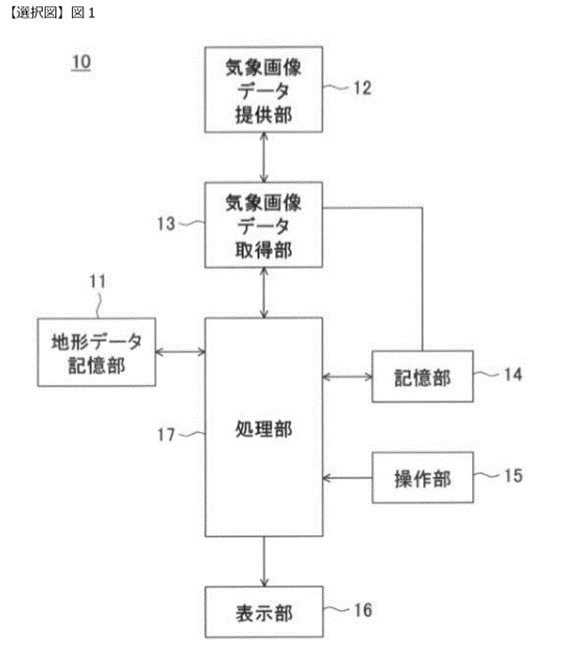
竜巻発生予測方法および竜巻発生予測装置
特許第5905299号
地形形状解析による竜巻発生予測方法の発生地域の危険度解析では、日本での過去最大級のEF3の北海道佐呂間町の竜巻、茨城県常総市~つくば市の竜巻、及び米国でのコロラド州他のEF5の竜巻についてその地形形状の検討をしています。この検討結果をもとに、地域危険度解析データを作成します。
WHIRLWIND OCCURRENCE PREDICTION METHOD AND WHIRLWIND OCCURRENCE PREDICTION DEVICE
PROBLEM TO BE SOLVED: To accurately predict a whirlwind.
SOLUTION: A meteorological image is added in order to predict an occurrence of a whirlwind, and topographic data is referred to. A whirlwind occurrence prediction method acquires meteorological image data showing low pressure (S2), makes the meteorological image data to be a three-dimensional image (S3), calculates lightness difference of a three-dimensional meteorological image, detects low pressure that causes a whirlwind from the calculated lightness difference (S4), analyzes a movement route of the low pressure (S5), confirms whether hill topography having the possibility of causing a downstream air current that can cause a whirlwind exists within the low pressure and a predetermined range in a direction ahead of the movement route of the low pressure (S6), confirms a change in strength of the low pressure in the case that the hill topography exists within the low pressure and the predetermined range (S7), and predicts an occurrence of a whirlwind by estimating the change in the strength of the low pressure (S8).
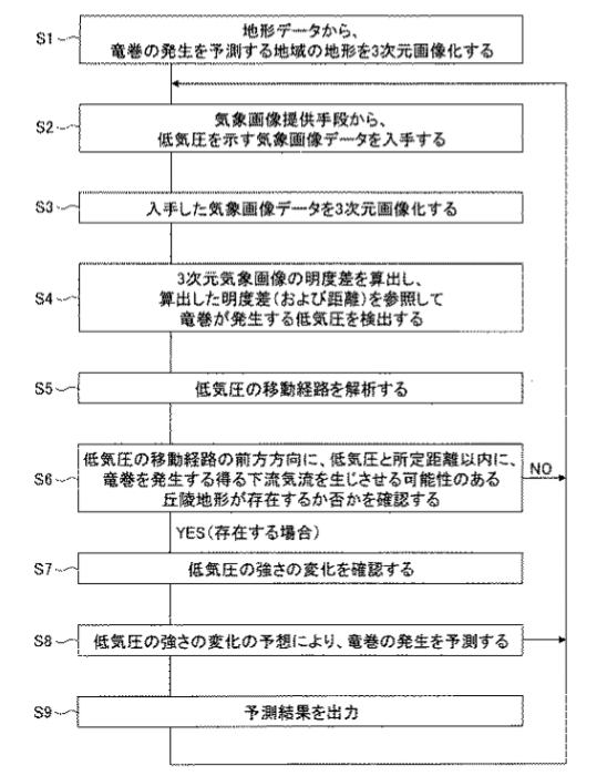
榎田、竜巻発生予測方法および竜巻発生予測装置、特許第5905299号(特願2012-046573)、登録日2016.3.25
特許内容はhttps://www.j-platpat.inpit.go.jp/web/all/top/BTmTopPageで参照可能です。
建築物
特許第5936886号
建築物では2011年3月11日の東北地方太平洋沖地震で、仙台市内の海岸付近の建物の大半が津波に流された経験を基に、建築物の地震時対策として必要壁量を確保し、開口を1階に設け、その壁の配置計画により、効率よく津波を流す手法で設計することを目的としています。
BUILDING
PROBLEM TO BE SOLVED: To provide a building capable of being restrained from being swept up by a tsunami.
SOLUTION: In a building with two or more stories, a first-story section F1 includes an earthquake-resisting wall 5 facing a horizontal x-direction, and an earthquake-resisting wall 5 facing a y-direction orthogonal to the horizontal x-direction. Clearances 7XA and 7XB, which allow a tsunami to flow through the first-story section F1 when the tsunami reaches the building and which linearly pass through the first-story section F1 in the x-direction so as to ward off tsunami energy, and clearances 7YA and 7YB, which linearly pass through the first-story section F1 in the y-direction, are formed.
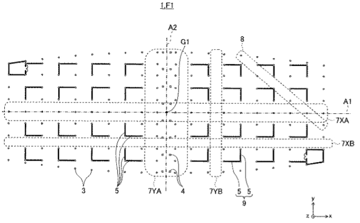
榎田、建築物、特許第5936886号(特願2012-049623)、登録日2016.5.20
特許内容はhttps://www.j-platpat.inpit.go.jp/web/all/top/BTmTopPageで参照可能です。
竜巻発生予測装置及び竜巻発生予測方法
特許第6180188号
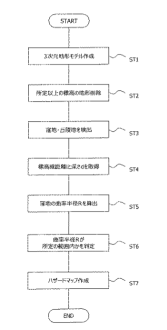
特許第5905299号(3)の地形形状の検討に続き、この特許では地形の垂直方向の形状について検討を行います。その地形形状について、竜巻発生地域のハザードマップを作成するもので、積乱雲の大きさと地形形状からそのマップを作成します。特に関東平野はそのマップから竜巻発生多発地域として表示されます。また、米国の中部、中東部地域も同様にそのマップから竜巻発生多発地域として表示されます。日本全国と米国の中部、中東部地域の詳細なハザードマップを作成します。
WHIRLWIND OCCURRENCE PREDICTION DEVICE AND WHIRLWIND OCCURRENCE PREDICTION METHOD
PROBLEM TO BE SOLVED: To predict whether a region has a landform where a whirlwind easily occurs or not; and to predict whether a whirlwind may cause a great damage or not, when predicted that the region has a landform where a whirlwind easily occurs.
SOLUTION: A whirlwind hazard map can be formed, in which a hill area adjacent to a depression is extracted and determined to be a region having a possibility of occurrence of a whirlwind, and the region is emphasized, and in particular, when the curvature radius R of the depression is within a prescribed range, the region is strongly emphasized because of having a possibility of occurrence of a whirlwind which may cause a great damage.
榎田、竜巻発生予測装置及び竜巻発生予測方法、特許第6180188号(特願2013-109149)、登録日2017.7.28
特許内容はhttps://www.j-platpat.inpit.go.jp/web/all/top/BTmTopPageで参照可能です。
研究歴
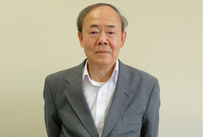 榎田寛治 Hiroshi Enokida
工学博士、一級建築士
建築構造解析を主に研究しています。鉄筋コンクリート構造や壁式構造の応力解析を主に行っています。2007年3月の能登半島沖地震を機に、地震発生予測について研究し、その予測に気象画像と地形形状を利用しています。2006年の佐呂間町の竜巻では同様に気象画像と地形形状を利用して地域危険度を解析しています。
研究所
| 研究所名 | 株式会社榎田建築物防災技術研究所(EnokBDP-IT) |
| 代表者 | 代表取締役社長 多紀章子 |
| 所在地 | 横浜市青葉区奈良2913-7 |
| 連絡先 | info(@マーク) enokbdp-it.com |
| 研究内容 | ・気象画像データ解析による地震等の災害予測及びその建築物災害予防のデータ提供 ・地形形状解析による竜巻等の発生地域の危険度解析及びその建築物防災予防データの提供 ・津波防災対策及び建築物防災予防データを基にした建築物構造計画に関する情報の提供 ・上記に付帯関連する一切の業務 |